"Good morning, I wanted to inquire about the whereabouts of your employee and whether he is already on his way? He was supposed to be here 25 minutes ago. When can I expect his arrival?"
You are currently busy with various tasks when the phone rings. At the other end of the line is an upset customer inquiring about the whereabouts of your employee and wanting to know why he has not arrived yet and when they can expect the employee's arrival. You would like to provide answers to the customer's questions, but at the moment, you are unsure of exactly where your employee is.
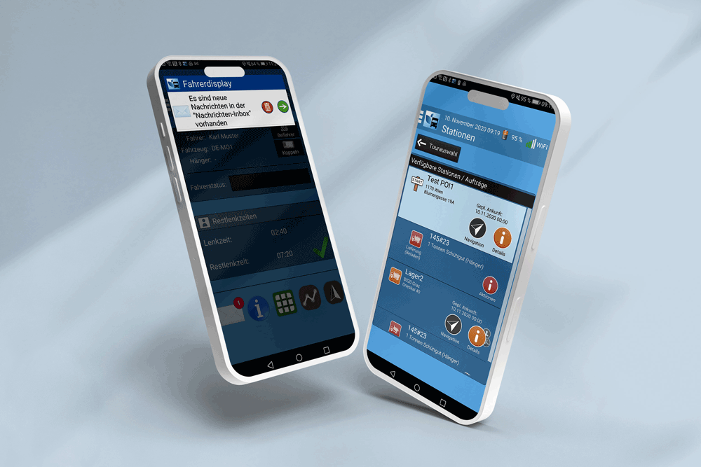
BlueLOGICO® can help you avoid these kinds of unpleasant phone calls because with BlueLOGICO® and the TEOS® app, you can bring transparency to your fleet and your processes.
Telematics sheds light on the situation
With telematics software like BlueLOGICO®, you have full visibility of your fleet. For example, you always know where your vehicles are located, when they will arrive at their destination, monitor the remaining driving times, and can receive notifications for certain events (e.g., arrival at the customer's location). The transparency provided by telematics helps you further improve the service level to your customers.
How Geofencing can spare you these unpleasant phone calls
Geofencing revolves around the relationship between your vehicle's position (or the driver's TEOS® app) and the "fenced" location. The term Geofencing is formed from two English words: geographic and fence. So, when referring to Geofencing, it means an imaginary boundary around a geographical area. You can think of such a "geo-fence" as simply an invisible digital boundary around a location (e.g., your branch office).
When your driver enters or exits the defined area (e.g., the customer's premises), an action is triggered. Such an action could be an automated message informing you or your customer about the driver's arrival.
Automatic notification upon arrival
In BlueLOGICO®, you have the option to create a Geofence for each of your customers. If your driver enters the predefined area (e.g., a construction site), the customer can be automatically notified by email. For example, when the driver arrives at a large construction site, the customer is notified in real-time and can prepare the team and equipment for optimal resource deployment. Waiting times and uncertainty can thus be minimized.
Improving punctuality
Only what is measurable can be improved. With Geofencing in BlueLOGICO®, every arrival at the customer's location can be documented as an event. Additionally, you are notified directly upon your driver's arrival at the customer's location (notification, email, or SMS). This allows you to immediately determine whether your driver is still on schedule. If there is a delay, you can react promptly and continuously improve punctuality at the customer's location.
Documentation / Control
With Geofencing, you can document not only delays at the customer's location but also a variety of other events. In general, Geofencing allows you to easily document all entries and exits into or out of the defined zone. Our customers use Geofencing for documenting the following events, among others:
- Departure from the company premises
- Arrival at the customer's location
- Deviation from the planned route
- Start of work at the customer's location
- End of work at the customer's location
- Exclusion of the use of highways or dangerous roads
Conclusion
A telematics system like BlueLOGICO® supports you in always having an overview of your fleet and allows you central access to all fleet-relevant information. To spare you unpleasant phone calls and increase transparency towards your customers, we recommend utilizing the Geofencing feature. With Geofencing, you can delineate areas such as your customer's premises with an imaginary fence and receive notifications for your driver's entry into or exit from these areas. In addition to automatic notification upon entry or exit into certain zones, Geofencing helps you improve punctuality at the customer's location and allows you to document various events such as deviations from the planned route or arrival at the customer's location.